Thursday, December 24, 2009

Lanikai Pillboxes - Kaiwa Trail

Trails: Lanikai Pillboxes - Kaiwa Trail
Distance: Just under 2 miles round trip
Elevation Gain: about 600 ft
Hiking time: 1 hour
Area: Kailua Lanikai - Windward side of Island
Trailhead: 301 - 499 Kaelepulu Dr., Kailua, HI 96734
Trailhead Coordinates: N21 23.424 W157 43.169
Sights: Kailua, Lanikai, Windward coast and Koolau Range
Directions via bus: Click here for Google Maps transit directions from Waikiki
Directions via car: Click here for Google maps directions from Waikiki The trail head is near the entrance to a private community and next to a golf course. As you are going up Kaelepulu Dr, when you see the culdesac, you'll see a private road to the left. You'll notice a trail on the right side of the private road.

Recommendations for hike: Sunscreen. There's no shade so make sure you have sunscreen and some sunglasses and/or hat (becareful of the strong winds though). Though it can be done in slippers, I would recommend sneakers. Some of the terrain is loose and rocky along the steeper parts. Boots are unnecessary. Water. No need for bug spray.

The yellow path is the trail


This profile is to and back.


After walking all of Kailua beach, Nicole, her mom, and I headed to the Lanikai Pillboxes (as it's commonly referred to). This is a relatively easy and short hike that over looks Kailua and Lanikai. Lanikai means "heavenly sea" in Hawaiian and has been on various lists of top beaches across the world.

The hike is along a well marked trail. It's a popular trail and well traveled by tourists and locals, sometimes with there dogs. Certain parts are rock scrambles but they are short and simple. We started off and the trail follows along a fence of the neighboring residential community. I'm sure they don't like the fact that so many people go there but screw them. It's public property and trails like this shouldn't be closed off.

As we climbed up to the pill boxes (bunkers), we saw this little chihuahua climbing up. It couldn't be more than 8 lbs. This tiny little thing seemed to struggle a bit but made it up. Most people head to the pill boxes and stop. The trail actually continues up and down the low lying peaks. As you continue we think we spotted Bellow's Air Force Base and could see Waimanalo Beach. There were some great views of Kailua and Lanikai too. Looking South, you can also see the Koolau Range and Olomana peaks. The trail actually descends down into another residential area.

Overall this is a nice casual hike with a bit of climbing. It's short and quick and conveniently located near Kailua Beach Park. Enjoy.


 Lanikai beach, looking North
 
 Some interesting vegetation on the way up. The individual plants looked like cactus stalks (not sure if that is the right term). They were thick and had a semi-waxy look to them.


Saturday, December 19, 2009

Sunrise at Koko Head Crater

For details and technical data of this hike, please see my prior posts. Go to the my hiking guide via the labels on the right and it will be listed.

So since I was up a 3:00 am to drive my friend and her family to the airport, I decided to go back to Koko Crater to catch the sunrise. Got there at 5 am.... so tired... complete darkness... fortunately I just did the hike last week so I'm pretty familiar with the area. Still took me 40 minutes to get up there. Not getting any faster and still need to take a lot of breaks... I'm trying to prepare for Haiku stairs which is about 4000 steps and a gain of 2800 ft. We'll see.

I had a chance to see Molokai in the distance and a nice sunrise! I was talking with a guy, Shawn, up there. Every day he hikes up and watches the sunrise. He's done it for a couple of weeks now. It's the simple things you do that make life enjoyable.


Thought this was pretty cool. Don't know how I got this effect. It's like the city is evaporating!!


Same area as above but daytime.


Hanauma Bay right before sunrise

Looking past Sandy's beach just before sunrise.
First sight of the sun, rising up from behind Molokai
       

Thursday, December 10, 2009

Bye Hawaii!

I will miss this place... earlier... lying on the sands of Waikiki... stars out... clouds playing... this place has brought me peace and beauty. People fret around the streets behind me... they should stop and look up.. and around. Few come to the beach at night... but I hope they share the same realization as I do... this place brings serenity.

I will miss this place... for the past couple of weeks... when i made the decision to leave... i've pondered about everything I'll miss... the simplicities.... beaches... waves... starlight... the sun... the mountains... its dynamic landscape... looking to the North and seeing a majestic ridgeline... filled with tiny intricate crevasses... clouds sometimes hugging the peaks... rays of sunshine peering through... and to the South... a beach filled with life... though manufactured... still beautiful.

I will miss Hawaii... thank you...

Tuesday, December 8, 2009

"The Eddie" at Waimea Bay 2009

The Eddie is a invitation only surf competition held on Oahu's North Shore at Waimea Bay. I is not held every year and is in the memory of Eddie Aikau. It is held by Quicksilver only when the waves are big enough. There's a lot of information on hi on the web. Check out http://live.quiksilver.com/2009/eddie/history.php?btn_history=_over for more information.

So Tuesday morning at work. I've never gotten into the surf culture just cause I never got into surfing but I've been meeting to hit up the North Shore to watch. I heard that they might be having The Eddie this week. It's big news on the island. Enough that hordes of people are calling out of work, I imagine a lot of the surf shops are closed, and enough to create a major traffic jam in and out of the north shore. Since it's not held every year and I'm going to be leaving soon = once in a lifetime chance to see this competition!

So after sorting things out with the therapist for the rest of the day... I'm off! Pick up some water and food and wait at the bus. While at the station, started talking to this guy, Craig, from Scotland. He just arrived yesterday night and was going to The Eddie. Pretty nice guy and we shared some stories. So 30 minutes or so and I get a call from Dori, she's on her way up. Sweet! We meet in Kaneohe, dude from Scotland comes with us, and so begins the day.

After 2 more hours of driving and some walking we're there. Oh my god! It's ridiculous on the North Shore. Hordes is an understatement. The walk ways, beach, rocks, and practically everywhere was filled with people. After climbing down some steep rocks, we make our ways to the edge of the rocks. Those people on the beach thought they had a nice spot... yeah right. This was so close to the break. It's amazing to watch these guys conquer these walls of water!!! And just shows how powerful the ocean is!!

 This is at a beach on the way to Waimea
 
 Shark's Cove. People normally snorkel here.
 
 Waimea!


 Ended up at that end point along the rocks.
 
 Told you it was crowded.


 Intense!


Sunday, December 6, 2009

Koko Head Trail - Full Loop

Trails: Koko Head Trail - Full Loop - not Koko Crater
Distance: Just under 3.5 miles round trip
Elevation Gain: about 1000 ft
Hiking time: 2.5 hours including time to explore the edge a bit
Area: Hawaii Kai - East end of Island - Hanauma Bay Ridge
Trailhead: Hanuma Bay Entrance
Trailhead Coordinates: 
Sights: Hanauma Bay, Koko Crater, Hawaii Kai Marina, Diamond Head
Directions via bus: Take the 22 to the entrance to Hanauma Bay or any bus to Hawaii Kai and walk up Kalanianeole Rd to Hanauma Bay.
Directions via car: Take H1 East, past Diamond Head into Hawaii Kai. Continue straight and it will eventually become Kalanianeole Rd. It will go uphill, curving left. On the right, you'll find the entrance to Hanauma Bay. Go down and park and walk back up to the entrance.
Recommendations for hike: Sunscreen!!!. There's no shade so make sure you have sunscreen and some sunglasses and/or hat (becareful of the strong winds though). Though it can be done in slippers, I would recommend sneakers. Some of the terrain is loose and rocky along the steeper parts. Boots are unnecessary. Water. No need for bug spray.


 The overlapping red trail is the previous trail.
 

 So Nicole, Hillary, and I went back to Hanauma Bay today to hike the full loop of Koko Head. Last time, we didn't have much time for the full loop. This is not to be confused with the more popular Koko Crater. I forgot my camera but wanted to provide the technical data on the loop.
So we took a counter-clockwise approach this time. Instead of trailing of the paved road, we continued on until we past some stations. Eventually we came across a dirt road on the left that quickly descended towards the ocean. It wraps around towards the edge where you can see Hanauma Bay
Once at the point, I went back down to the edge of the coast again via the same rope. At once again I was fascinated to the layered rock and tiny crevices in the hill side. I'm glad that Hillary braved the descent to the edge as she quickly learned it wasn't so bad. Totally worth it.

Sorry no pics, forget my camera.

Monday, November 30, 2009

Maakua Gulch Trail

Important Note: THIS TRAIL IS CLOSED (which i found out after the fact *wink*). SOME BOOKS MAY STILL HAVE IT LISTED AS AN OPEN TRAIL.
Trails: Maakua Gulch Trail
Distance: About 6 miles round trip (from the general entrance of the Maakua Trails to end of the gulch and back), this may be inaccurate since my GPS didn't really work towards the end of the gulch.
Elevation Gain:  once again unsure. At least 900 ft.

Hiking time: 3 1/2 hours
Area: Town of Hau'ula, Northern Windward side, South of Laie (Polynesian Cultural Center)

Trailhead: End of Maakua Rd
Trailhead Coordinates: N21 36.221 W157 55.113
Sights: Windward Shore, Papali Gulch
Directions via bus: From Ala Moana Center take the 55. It will go up the Pali, though Kaneohe, and up the windward coast along Kamehameha Highway. It's quite a long ride. You'll pass Koolau Ranch, Ka'awa, Kahana Valley, and Punaluu before getting in the area. Ask the driver to stop at Hau'ula Homestead Rd in Hau'ula. Follow Hau'ula Homestead Rd. Right before it curves to the left, follow Maakua Rd. After a short walk, you'll see a sign that says "Maakua Trails." Right up the road you'll see a gate to the left. This is your starting point.

Directions via car: From Waikiki, take H1 West. From here you have multiple options. You can take Likelike Highway, Pali Highway, or H2 through the mountains. Then make your way onto Kamehameha Highway going Northwest. Pass Koolau Ranch, Ka'awa, Kahana Valley, and Punaluu before getting in the area. Make a left onto Hau'ula Homestead Rd and before it curves to the left, follow onto Maakua Rd until you reach a gate on the left. I've seen cars park right around the gate but there isn't much parking available.


Recommendations for hike: I recommend shoes or hiking boots for traveling along the stream bed. Muddy at parts and rocks are slippery. Your feet will get wet. Bug repellant is recommended. Water and bathing suit/trunks.
Trail Conditions: This follows Maakua stream all the way to the end. It starts as a trail bu quickly alternates between trails and going up the stream bed. Eventually, you'll have to follow the stream along into the gulch. It gets narrow and you're surrounded by the mountains. Your cell phone and GPS will probably not work once you enter the gulch.


 Yellow is the Maakua Gulch Trail from the gated entrance. Look what my GPS did!! It got lost!

 
Since my GPS was on the fritz... this can't be accurate. I know the first 2.5 miles is accurate. There's a section in the middle where it is jumping around. 


This is a more interesting hike than I had anticipated! I've never done a gulch hike. It enters an ever winding gulch following a stream to the end.

So as I departed from the previous loop trail, I decided to do another hike. I just wasn't satisfied with the previous 3 mile loop. So I ventured back on to the utility road and followed it all the way down. Eventually I reach some sort of water station, made my way around, and found the trail head. At first, there were a series of pine trees but that soon stopped. After crossing a small stream and descending a little bit, the trail began to follow a dry stream bed.
The trail became unclear. It was unmaintained and as I followed it, I saw that many of the markers had fallen off. I ended up just walking along the dry stream bed.  The first half of this trail was quite muddy along the side trails though the bed was dry and the mosquitoes were getting on my nerves. What a pain? As soon as I stopped I was swarmed. A bit unsure if there would be any stream and a bit lost, I was reluctant to continue. I'm glad I did though.
The trail continued along the side of the stream bed, onto the bed, and back. There were some forks following the bed. Wasn't sure where to go. It didn't matter. Soon I found that the stream bed split and converged multiple times. And soon enough in the next 3/4 or so, my first sign of water. Just a small section of it but it was so clear. It's the clearest stream that I've seen on the island. Perhaps because there wasn't much soil around. Little by little, more and more water and it finally became a stream. Skipping from rock to rock, I avoided getting wet for quite a while. But as the gulch narrowed and the stream became more fluid, I had no choice.
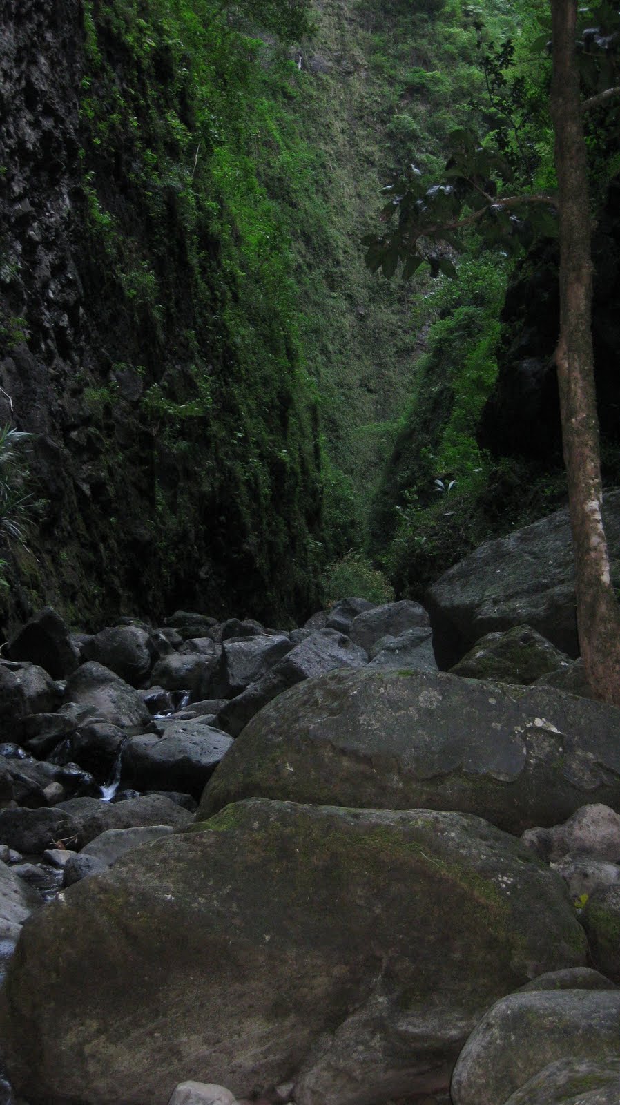
Being in a gulch is interesting, eerie, and oddly refreshing. I was surrounded by walls covered in green at least 100 ft high. Huge rocks layered the gulch. I knew I had to be alert in case of a rock fall. A severe one would be deadly. My paranoia kicked in and thought what would happen if I injured myself that far in. No phone. No way that anyone could hear me. An unpopulated trail. Not good. But.. I had to reach the end. Another factor was the daylight and weather. It had been overcast in the mountains and valleys that day. If it started raining, well a flash flood could occur. Plus it would just increase my chances of me slipping. There were little places for shelter. Daylight seemed to be fading but it was only because it was narrowing. I had to reach the end and started picking up my pace.
I got impatient... the gulch didn't seem to end. Winding left and right and left and right into the valley, it got narrower. It started off relatively wide, maybe 30 ft across. By the end, where I could see the waterfall, it only spanned 10 ft. Right at the waterfall, it was only my arms span across.
The waterfall was amazing though. I've never seen one in such an environment. It was a small waterfall and swimming hole. Enough to wade around and cool off. I noticed something behind it. Where was the water coming from? I could go a bit further but had to leave my gear. As I climbed up, it bended to the left. A bit of climbing on some slippery rock and another larger swimming hole and slightly larger falls. Maybe a dozen feet or so high. I was just so impressed with the environment. Miles away from a civilization (I know it's not that much)... it was peaceful and secluded. Walls towering above me. Light shining through the narrow opening above. Quite spectacular.
Enjoy the pics!

Uhhh... area closed? So after some quick research... the trail is closed. Explains why it was not maintained.


Entrance to the trail.


First immediate stream crossing... not Maakua Stream though.


Not too promising...


Where's the water?


Yes first sign of water!


Forward!


 Looking up.


I thought this was the waterfall and maybe it was dry. I was wrong.


Deeper into the gulch.


Looking up again towards the end the gulch.


It never seemed to end.


Though there were some nice tiny (maybe a foot) along the way.


Finally a falls. Still not too impressive. At that part, it was only like 5 ft across. Wasn't too deep.


Wait! I can go further!


Okay so these aren't the best pics. The final falls was at least 6 ft and pool was nice. Still relatively narrow though but just so peaceful. It was such a pain to get these last 3 pics. I had to swim with camera above water. I'd just hate to lose a camera and all the pics. But hey... it worked out. :)